-40%
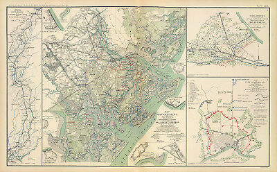
1895 Savannah Civil War Map Union Confederate Armies Military Wall 10x16 Poster
$ 6.6
- Description
- Size Guide
Description
1895 Map of Savannah, Ga. and vicinityDetailed Specifications
This is a reproduction of the original map.
Map Size: 10"x16"
This Map Comes in other Sizes too:
16"x26" and 23"x37"
You can find it and more
War
related
Maps
in
Our Store
We have more
War Posters
in
Our Store
All Our Posters and Maps Are Made in the USA
Atlas to accompany the official records of the Union and Confederate armies.
Illustrating the operations of the army under
command of Maj. Gen. W.T. Sherman resulting in the fall of that city December
21, 1864.
Inset maps: Fort Thunderbolt, Fort Tattnall
Bastion on the line of defense across Whitemarsh Island
Battery on Turner's Rocks --
Works at eastern point of Whitemarsh Island
Fort McAllister
Causten's Bluff, Fort Lee.
Showing the route of march of the 2d Division, 15th Army Corps from November 12th to December 21st 1864.
Rebel defenses in front of the 14th and 20th Army Corps before the evacuation of Savannah, Ga.
Map of the city of Selma, Ala. and its defenses.
This map comes with a white border around the image
---------------------------
-How are the prints shipped?
They are rolled and placed into a rigid tube.
-Is this available in a larger/smaller size.
Yes. For smaller or larger sizes, email us.


